Drag-Queen für Kinder – wenn es zu bunt wird
Das Thema „Trans“ an Kinder zu bringen, ist ein Trend, der nicht ohne Wirkung bleibt und sehr offensichtlich vor allem auch #medial gepusht wird. Auch in #Deutschland finden zum Beispiel mehr und mehr #Draglesungen für Kinder statt.

Wenn man früher Kindern mit Hilfe von Literatur beibringen wollte, dass das Leben „bunt und vielseitig“ ist, dann reichten die #Kinderbücher vom glitzernden Regenbogenfisch oder auch Pippi Langstrumpf völlig aus. Heute werden Männer in Frauenkleidern vor #Kindergartenkinder gesetzt, damit sie das bunte pralle Leben, das sie als Erwachsene erwartet, einmal so richtig kennenlernen. Dazu werden Bücher gereicht, die ihnen erklären, wie Papas in ihrer Bauchhöhle jetzt Kinder kriegen, wie der Prinz seinen Prinzen und man als Erstklässler das richtige Klo findet, aus welcher Samenspende wer gezeugt wurde und wer jetzt nun alles ein rosa Tutu tragen darf. Es wimmelt von Tierkindern, #Regenbogenfahnen und gerne auch Onkeln mit tiefer Stimme und Frauenkleidern.
https://www.achgut.com/artikel/drag_queen_fuer_kinder_wenn_es_zu_bunt_wird
Corona-Aufarbeitung: Ein Unschuldsengel vor dem Untersuchungs-Ausschuss
Ein offizieller Corona-Untersuchungsausschuss brachte Lothar Wieler und eine Vertreterin des Paul-Ehrlich-Instituts ins Schwitzen. #CDU und #AfD quetschten die beiden Zeugen aus. Nicht möglich? Im Brandenburger Landtag durchaus. Die Achse war vor Ort.

Im Brandenburger #Landtag hat am Freitag auf Länderebene stattgefunden, was auf Bundesebene hintertrieben wurde: ein #Corona-Untersuchungsausschuss. In seiner ersten Sitzung vernahm er illustre Zeugen: den ehemaligen #RKI-Chef Lothar Wieler und Dr. Brigitte #Keller-Stanislawski, die im #Paul-Ehrlich-Institut für die Pharmakovigilanz (Überwachung) der #Corona-Impfstoffe zuständig war und am Samstag ihren ersten Tag in Rente antrat. Die angedachte Vernehmung der Zeugin Britta Ernst (des Kanzlers Ehefrau) als ehemalige Ministerin für Bildung, Jugend und Sport des Landes Brandenburg wurde aus Zeitgründen abgesagt. Sie warb 2021 für die Kinder-Impfung.
https://www.achgut.com/artikel/corona_aufarbeitung_ein_unschuldsengel_vor_dem_untersuchungsausschuss
Deutschland eifrig Spitzelland
Die #Bundesregierung lässt über 100.000 Meldestellen einrichten, bei denen Beschäftigte Hinweise auf Straftaten melden können. Vorgeschrieben ist dies im neuen #Hinweisgeberschutzgesetz. Das Gesetz könnte eine Welle von Denunziationen auslösen. Der Autor ist Historiker und war bis 2018 Direktor der Stiftung Gedenkstätte Berlin-Hohenschönhausen.
Der Satz erinnert an eine #Stasi-Richtlinie: „Die Personen, die in einer Meldestelle für die Entgegennahme von Meldungen zuständig sind, dokumentieren alle eingehenden Meldungen in dauerhaft abrufbarer Weise unter Beachtung des Vertraulichkeitsgebots.“ Die Anordnung stammt indes nicht aus der Feder Erich Mielkes, sondern aus einem Gesetz des Deutschen Bundestages. Rund 90.000 Unternehmen sowie tausende öffentliche Einrichtungen müssen danach sogenannte Meldestellen einrichten, bei denen Beschäftigte Vorgänge melden können, die ihrer Ansicht nach gegen Recht und Gesetz verstoßen.

Weitgehend unbemerkt von der Öffentlichkeit wird in #Deutschland in diesen Wochen ein neues #Meldesystem für Hinweise auf Straftaten aufgebaut. Arbeitgebern, die sich nicht daran beteiligen, droht eine Geldbuße von bis zu 20.000 Euro. Zusätzlich bilden Bund und Länder sogenannte externe #Meldestellen, die betriebsübergreifend ihre Dienste anbieten. Die über 100.000 neuen Meldestellen sollen nicht nur passiv Meldungen entgegennehmen, sondern auch eigene Untersuchungen durchführen. Auf diese Weise entsteht ein neuer, riesiger Ermittlungsapparat, der weder im #Grundgesetz noch in den Verfassungen der Länder vorgesehen ist.
https://www.achgut.com/artikel/deutschland_eifrig_spitzelland
Das Wetter als Glaubenssache
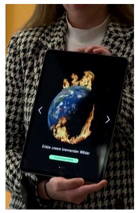
Von der #ARD hysterische Berichte über sommerliche #Hitze, Sprachvorschläge zur Abwertung Andersdenkender und eine Wetter-App für Kinder, die die Erde mit Spezialeffekten brennen lässt. Vom #ZDF ein Leitfaden zur alarmistischen Wetterberichterstattung. Vom #Gesundheitsminister ein Lob für die Willfährigkeit der #Öffentlich-rechtlichen bei der #Hitzeberichterstattung. Zusammen ergibt dies das Bild einer Kampagne, die das wissenschaftliche und gesellschaftliche Ringen um die richtige Diagnose und Therapie zugunsten eines Dogmas unterdrücken soll.
https://norberthaering.de/propaganda-zensur/world-weather-attribution/
Das Versprechen, dass sich die NATO nicht nach Osten ausdehnt
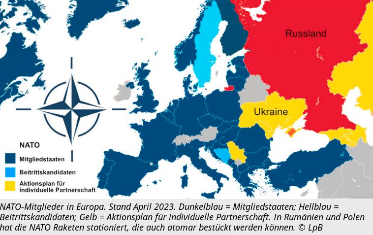
Jacques Baud / 12.08.2023 Die #NATO an der russischen Grenze verkürzt bei einem Angriff die Reaktionszeit und erhöht das Risiko eines Atomwaffeneinsatzes.
75 Jahre Grundgesetz - Vielsagende Passagen in der Erklärung von Bundespräsident Steinmeier
Das Deutsche Grundgesetz feiert seinen 75. Geburtstag. Aus diesem Anlass durfte #Bundespräsident #Steinmeier einen Gastbeitrag im Spiegel veröffentlichen, der sehr vielsagende Passagen enthält.
Das Deutsche Grundgesetz, daran sei erinnert, wurde unter Aufsicht der US-Besatzungsmacht ausgearbeitet. Das #Grundgesetz wurde so gut, wie es unter diesen Umständen eben werden konnte. Eine #Volksabstimmung darüber gab es nicht und der Verzicht auf die Bezeichnung als „#Verfassung“ sollte den provisorischen Charakter des Grundgesetzes und der mit ihm gegründeten (ebenfalls als provisorisch angesehenen) Bundesrepublik #Deutschland betonen. Der Parlamentarische Rat, der das Grundgesetz ausgearbeitet hat, war der Auffassung, dass das Deutsche Reich fortbestehe und eine neue Verfassung für den Gesamtstaat daher nur von allen Deutschen oder ihren gewählten Vertretern beschlossen werden könne, was wegen der Besetzung von Teilen Deutschlands durch andere Siegermächte unmöglich war.

Staatsfunk will das Framing-Monopol
Die ARD bestellt ein Framing-Manual, man gibt Empfehlungen zur #Klimasprache und dergleichen – aber „#Zwangsgebühr“ findet man doof, weil es ein „geframter Begriff“ sei. Oha! Die sind nicht gegen Umdeutung – die wollen nur ein #Monopol darauf! Ein Staatsfunk-Monopol, quasi.

Nein, nein, nein, das darfst du nicht! Ich darf das, natürlich, aber Du darfst das nicht! – So oder so ähnlich klingt ein ganz wesentlicher Pfeiler der inneren Moral unserer sogenannten Guten. Aktuell erleben wir, wie sich einige Gutverdiener bei #ARD und #ZDF darüber aufregen, dass die den Bürgern mit Zwang und Androhung von Knast abgepresste Finanzierung des regierungsnahen Medienmolochs sachlich einigermaßen präzise „Zwangsgebühr“ genannt wird.
https://www.achgut.com/artikel/staatsfunk_will_das_framing_monopol
Laptops running FreeBSD
Laptops running FreeBSD
Testing and collecting technical information
NYC*BUG dmesgd
Automated upload
Laptop support
A-F
G-S
T-Z
Tablet support
Legend
To improve #FreeBSD support for various #laptops, please share your experience with a particular laptop #model you use daily or have occasional access to. This information can help users to decide if some model they want is worth buying to install FreeBSD and help interested developers to improve #hardware support.
Die globale Temperatur kann man nicht messen
Niemand kennt eine globale Temperatur. Niemand kann sie messen. Darum kennt auch niemand ein „#Weltklima“. Alle Worst-Case-Szenarien, mit denen man uns beschallt, beruhen auf Modellierungs-Hokuspokus.
Wie hoch ist die #Temperatur in #Hintertupfingen? Mal sehen. Beim Huberbauer im Stall sind’s am Morgen 15 Grad, mittags 24, abends 21, aber das war gestern.

Auf dem Marktplatz sind’s mittags 32 Grad. Im Keller von Tante Fine sind’s immer zwölf Grad. Der Kirchturm ist 80 Meter hoch, da waren es gerade 22 Grad, zwei Meter über dem Kirchplatz 23 Grad, am Boden 34 Grad, weil die Sonne draufscheint. Unter der Dorflinde ist’s aber kühler, nur hat da grad‘ keiner gemessen.
https://www.achgut.com/artikel/warum_man_eine_globale_mitteltemperatur_nicht_messen_kann
Der Deutsche Rat für Public Relations spricht eine Mahnung gegen Twitter und BioNTech SE aus. Beide Unternehmen haben im Zuge der Impfstoffdebatte im Jahr 2020 gegen das Transparenzgebot verstoßen.

Die BioNTech SE soll, nach Recherchen des DRPR, versucht haben, einen kritischen öffentlichen Diskurs im Rahmen des „People’s Vaccine Day“ im Dezember 2020 abzuwehren. Der Account des Impfstoffherstellers sollte für zwei Tage auf Twitter unauffindbar sein, um kritische „Kommentare etc. unmöglich zu machen“. Belegt wird diese Feststellung durch einen E-Mail-Verkehr zwischen BioNTech SE und Twitter-Verantwortlichen in Berlin.
Öffentlich-Rechtliche in der Kritik: Schummel fliegt auf: „Tagesschau“ gibt eigene Moderatorin als Kundin aus
Am Montag berichtete die „#Tagesschau“ über eine #Preis-Aktion bei #Penny. Dazu wurde auch eine mutmaßliche Kundin im #Discounter befragt. Doch die ist selber #Moderatorin bei den Öffentlich-Rechtlichen.
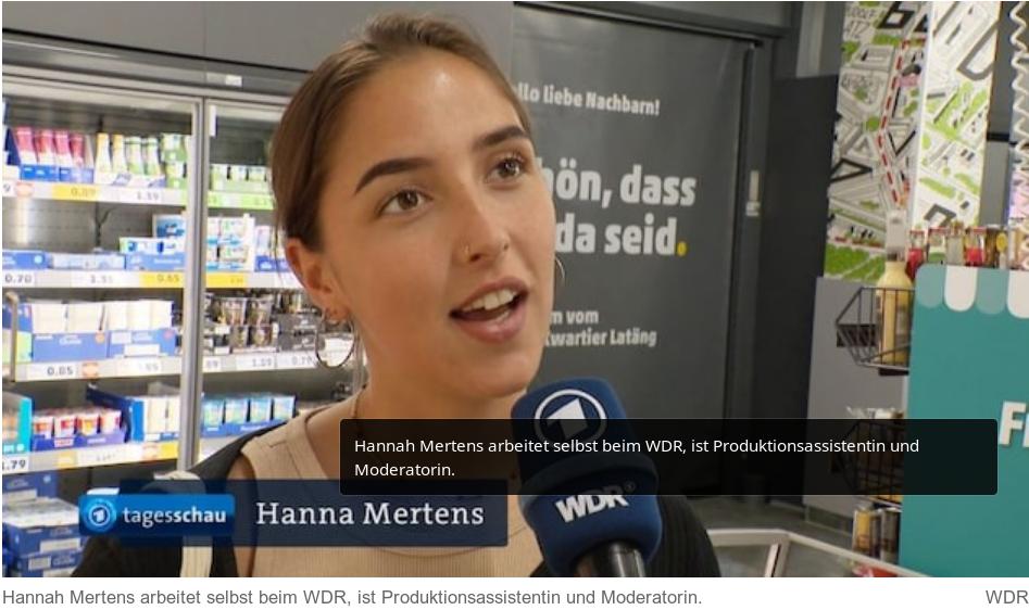
Anfang der Woche schlug die Preis-Aktion von Penny hohe Wellen. Der Discounter erhöhte seine Preise um bis zu 94 Prozent. Die Würstchen kosten diese Woche sechs statt drei Euro. Mit der Aktion will der Discounter Verbrauchern klar machen, wie teuer Würstchen oder vegane Schnitzel wirklich sein müssten.
Auch die „Tagesschau“ berichtete in einem vom #WDR produzierten Beitrag über die ungewöhnliche Aktion. In einem Penny-Markt wurden mutmaßliche Kunden zu der Aktion befragt. Doch bei einer Kundin handelte es sich in Wirklichkeit um eine Moderatorin des WDR.
Die Gender-Ideologie erobert die Schulen
In Großbritannien erklären Schüler, ihr Geschlecht zu wechseln, teils ohne Wissen der Eltern. Versuche der Regierung, dieser Praxis Einhalt zu gebieten, werden torpediert.

Rishi Sunak ist mit seinen Hausaufgaben in Verzug. Kürzlich sollte der britische Premierminister den Schulen aktualisierte Leitlinien für den Umgang mit der wachsenden Zahl von Schülern vorlegen, die ihre Geschlechtsidentität infrage stellen. Doch wieder einmal hat sich die Veröffentlichung verzögert. Und Sunak hat bereits eine Ausrede parat: Juristen der Regierung haben gewarnt, dass seine Pläne illegal sein könnten.
https://www.achgut.com/artikel/die_gender_ideologie_erobert_die_schulen
Unmasking the hidden gems of Void Linux
My previous article (Demystifying UEFI) had an outstanding response. It became the top post of the month on r/embedded and even made it to the top 10 of the year. It was even recognized by Google Discover, which I myself received as a recommendation, showing me the positive impact it had. So, I am grateful to everyone who found value in my last article.
It had got a lot of up's for and also questions as why I've been using #xbps to install dependencies.
So here I'll explain every single thing I saw and experienced that led me to make a permanent shift to #Void #Linux.

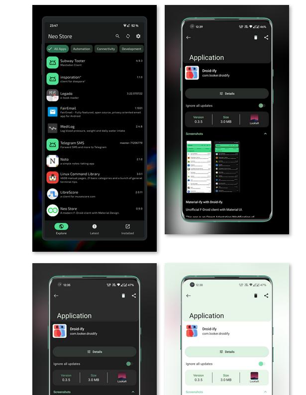
Neo Store - Ein moderner F-Droid Client mit Material Design.
Neu in Version 0.9.15
Add: KDE (Stable), C:Geo, Stack Wallet & PeterCxy's Shelter repos
Add: Option for external download folder
Add: Permissions page
Add: Downloads page (switch) to InstalledPage
Add: Option to ignore notification on security vulnerabilities
Fix: Background (silent) installer
Update: Improve preference dialog value setting
+ more than 40 commits & 30 translation contributions
Ein schneller material F-Droid Client
Features:
* Material #F-Droid Style
* Keine Cards oder unpassende Animationen
* Schneller #Repository Sync
* Standard #Android Komponenten und minimale Dependencies
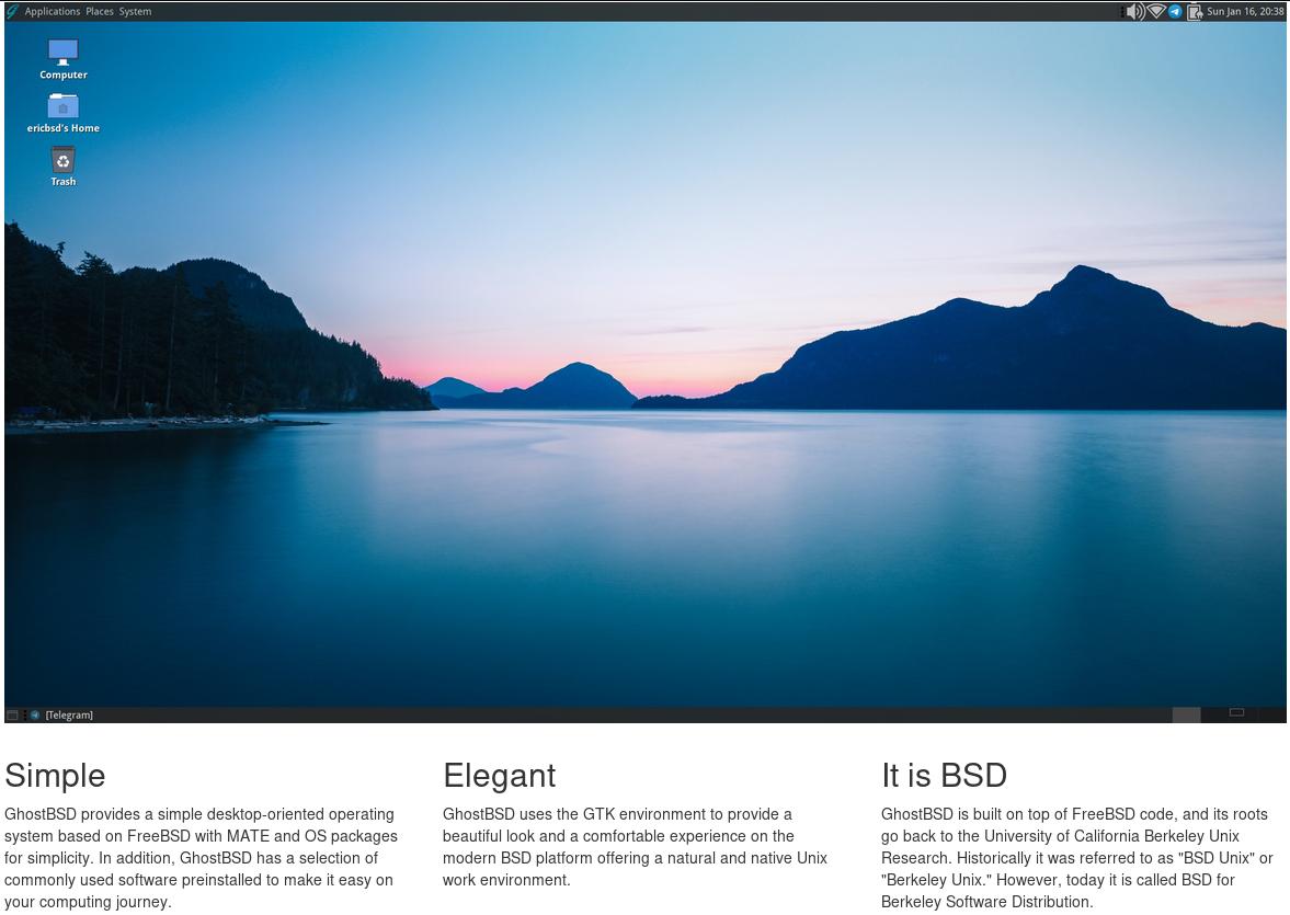
A simple, elegant desktop BSD Operating System - GhostBSD
Overview
GhostBSD is a simple, elegant, and friendly #BSD operating system for desktops and laptops based on #FreeBSD. #GhostBSD is a slow-rolling release while some GNU/Linux distros are on the bleeding edge side; we tried to offer a stable update and release cycle. The official desktop environment is #MATE. The system comes with a graphical application to install software and update your system. Most codecs to play multimedia files are pre-installed. The installer leverages #OpenZFS makes it easy to install GhostBSD on #ZFS with other #OS on the same drive, and is suitable for newcomers to #FreeBSD. With modest hardware requirements, GhostBSD is ideal for modern workstations and 64-bit single-board computer hardware.
Our Goal
In general, BSD is also considered beyond the average computer user's knowledge. We try to simplify FreeBSD to lower the entry-level of using FreeBSD on a #desktop or #laptop. We provide all the benefits of the FreeBSD operating system benefits combined with our in-house GUI tool.
Origins
GhostBSD is from Canada but has help from people around the world.
Free and Open
Our #source code is available on GitHub, and all the code we wrote is licensed under the Simplified BSD License. In addition, GhostBSD contains third-party software licensed under LGPL2, LGPL3, GPL2, and GPL3. It is available for free, but anyone who appreciates this software can donate, become a Patron on Patreon, and even become a sponsor of this project.
Custom map styles - OsmAnd
In this article, we want to show you how OsmAnd users create their own map styles.
OsmAnd map styles
At first about Map styles by default.
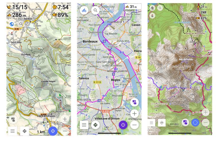
#OsmAnd contains own 10 map rendring styles: OsmAnd, Touring view, #UniRS and #LightRS, Nautical, Winter and ski, #Topo, #OSM-carto, Desert, #Offroad, Snowmobile.
Android version: Menu → Configure map → #Map #rendering → Map style
iOS version: Menu → Configure map → Styles for offline maps
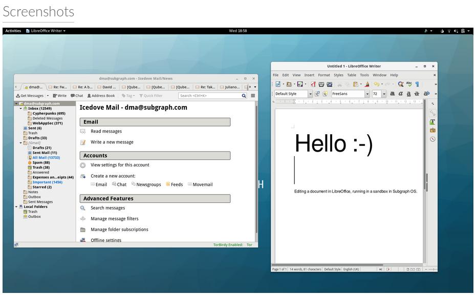
Subgraph OS: Adversary resistant computing platform
Subgraph believes that the best way to empower people to communicate and live freely is to develop technology that is #secure, #free, #open-source, and verifiably #trustworthy.
Subgraph OS is an important part of that vision.
The Internet is a hostile environment, and recent revelations have made it more apparent than ever before that risk to every day users extends beyond the need to secure the network transport - the endpoint is also at risk.
#Subgraph OS was designed from the ground-up to reduce the risks in endpoint systems so that individuals and organizations around the world can communicate, share, and collaborate without fear of surveillance or interference by sophisticated adversaries through network borne attacks.
Subgraph OS is designed to be difficult to attack. This is accomplished through system #hardening and a proactive, ongoing focus on #security and attack resistance. Subgraph OS also places emphasis on the integrity of installable software packages.
Impfskandal am Fließband

Von Dr. Kay Klapproth.
Offizielle Zahlen der dänischen #Gesundheitsbehörden offenbaren alarmierende #Nebenwirkungsraten bei bestimmten #Impfstoffchargen von #BioNTech/Pfizer. Gesetzlich vorgeschriebene Qualitätskontrollen finden offenbar nicht statt. Haben Hersteller und Behörden die Öffentlichkeit über die tatsächlichen Risiken der #mRNA-Präparate getäuscht? Versagen oder Vorsatz?
#Impfstoffe gegen #Covid-19 wurden nicht nur in Rekordzeit entwickelt und zugelassen, sie mussten auch in beispiellosem Umfang produziert werden, um den Bedarf für eine globale #Impfkampagne zu decken. Bedenken, dass unter solchen Bedingungen hergestellte Impfstoffe mit erhöhten #Risiken verbunden sein könnten, sollten zerstreut werden, indem uns eine systematische und lückenlose Kontrolle der Präparate auch nach ihrer Markteinführung versprochen wurde.
Nun zeigen allerdings die Daten dänischer Gesundheitsbehörden, dass die vorhandenen Sicherungssysteme nicht funktioniert haben. Der Verdacht besteht, dass Hersteller und verantwortliche Behörden vorhandene Sicherheitsrisiken vertuscht haben.
Der Sommerschreck im Hitzeschutzraum
Karl #Lauterbach feiert sein Comeback als #Sommerschreck und die #Länder und #Kommunen ziehen nach. In Castrop-Rauxel in Nordrhein-Westfalen wurden jetzt sieben #Hitzeschutzräume eingerichtet.
Es gibt neues aus der Rubrik „eigentlich zu lächerlich für einen ernsthaften Kommentar, aber zu relevant, um es unbesprochen zu lassen“: Die Stadt Castrop-Rauxel in Nordrhein-Westfalen hat sieben Hitzeschutzräume für heiße Tage eingerichtet. „Verschiedene Einrichtungen und Unternehmen in Castrop-Rauxel stellen ihre Räume als sogenannte Hitzeschutzräume zur Verfügung“, heißt es in einem WDR-Bericht. Und weiter:
„Den Anfang machen unter anderem städtische Jugendzentren, das Rathaus, das Familien- und Bildungsbüro sowie das Kundenbüro der Stadtwerke. Wer will, kann sich dort an einem #Sitzplatz ausruhen und auf Wunsch ein Glas #Wasser bekommen.“

https://www.achgut.com/artikel/Der_Sommerschreck_im_Hitzeschutzraum
Die preisgekrönte Opferdarstellerin
Die Vorsitzende des deutschen Ethikrates, Alena Buyx, demonstriert das Mindset einer politischen Klasse, die glaubt, jede Kritik als Hassrede delegitimieren zu dürfen. Auf Twitter lässt sich sehr anschaulich verfolgen, wie sie damit scheitert.
Die Vorsitzende des #Ethikrats bekommt von Markus #Söder den „Bayerischen #Verdienstorden“ verliehen. Unter dem Tweet hagelt es dafür harsche, argumentative, mehrheitlich keineswegs beleidigende Kritik. Daraufhin geriert sich #Buyx als Opfer einer Hatespeech-Kampagne: „1500 üble, teils menschenverachtende Kommentare“ seien das gewesen. Damit meint sie etwa die Antwort des Journalisten Alexander Wallasch: „Lassen Sie die Hater-Karte mal im Köcher. Die Leute sind zunächst mal zu Recht empört. Und Sie kennen den Auslöser: Diesen Orden anzunehmen nach Ihrer Rolle im Corona-Regime ist an Dreistigkeit nicht zu toppen. ‚Gewissenlosigkeit‘ ist da noch ein milder Anwurf.“ Ein Twitter-Nutzer fragt: „Meinen Sie allen Ernstes, die Menschen vergessen die #Gewalt, die ihnen wärend der #Pandemie-Politik angetan wurde? Und glauben Sie etwa, den Hauptakteuren dieser #Politik wird einfach so verziehen, ohne dass eine selbstkritische Aufarbeitung stattgefunden hat?“ Ein Fräulein Holle meint: „Dass sie einen Orden für Verdienste bekommen, ist wirklich ein Witz. Die Verweigerer einer Aufarbeitung der Coronapolitik hängen sich nun gegenseitig #Orden um den Hals. Wahnsinn!“

https://www.achgut.com/artikel/die_preisgekroente-opferdarstellerin/P9#comment_entries
Gentechnik für den Klimaschutz
Die #EU-Kommission will gentechnisch verändertes #Saatgut im Namen des #Klimaschutzes fördern. Damit ginge es der ökologischen #Landwirtschaft an den Kragen.
Die EU-Kommission teilte am 5. Juli mit, dass sie ein „Maßnahmenpaket für die nachhaltige Nutzung der wichtigsten natürlichen Ressourcen“ angenommen hat, mit dem auch die „Resilienz der Lebensmittelsysteme und der #Landwirtschaft“ in der #EU gestärkt werden soll. Klingt zunächst gut, ist jedoch bei näherem Hinsehen höchst problematisch: Zum einen sollen durch eine Richtlinie zur Bodenüberwachung die Böden in der EU „im Einklang mit dem Null-Schadstoff-Ziel bis 2050 in einen gesunden Zustand“ versetzt werden.

https://www.achgut.com/artikel/Gentechnik_fuer_den_Klimaschutz
Corona-Ticker: Wie das Narrativ zerfällt (9)
Das Corona-Narrativ zerfällt wie ein Soufflé, wenn man zu früh die Backofentür öffnet. Kaum eine Behauptung, die nicht früher oder später widerlegt wäre. Die Aufarbeitung ist zwangsläufig. Hier einige Meldungen aus den letzten Tagen und Wochen.

#Corona #Impfung #Impfnebenwirkungen #ARD #Medien #Medienmanipulation
https://www.achgut.com/artikel/corona_ticker_wie_das_narrativ_zerfaellt_9
Das EU-Militär im Kampf für den Klimaschutz?
Nun muss die vermeintliche Katastrophe des Klimawandels auch noch für eine Neuausrichtung des EU-Militärs herhalten. Das Militär soll künftig einerseits verstärkt bei klimabedingten Naturkatastrophen im Einsatz sein, andererseits soll es selber #klimaneutral werden.
Nicht nur das globale #Finanzsystem soll ‒ vorgeblich ‒ auf den #Klimaschutz ausgerichtet werden (wir berichteten hier), sondern auch die Streitkräfte der EU-Staaten. So veröffentlichte Josep Borrell, Hoher Vertreter der EU für Außen- und #Sicherheitspolitik, gemeinsam mit der #EU-Kommission am 28. Juni eine Mitteilung an das Parlament und den Rat der #EU mit dem Titel „Eine neue Strategie für den Klima-Sicherheits-Nexus: Zu den Auswirkungen von #Klimawandel und #Umweltzerstörung auf Frieden, Sicherheit und Verteidigung“.

https://www.achgut.com/artikel/das_militaer_in_der_eu_soll_fuer_klimaschutz_kaempfen/
DateilistenSchreiber
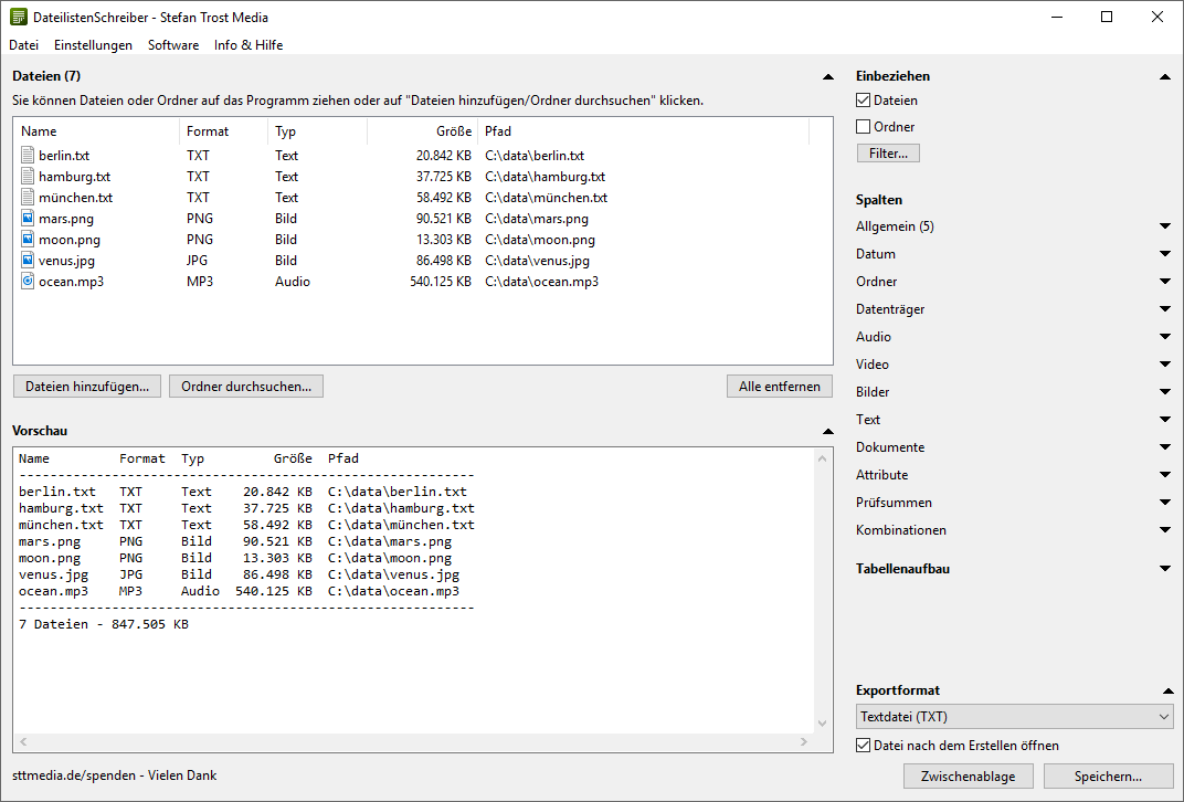
Zu den unterschiedlichsten Gelegenheiten werden #Listen von #Dateien oder #Ordnern benötigt: Sei es, um die Verzeichnisse und Dateien einer CD, DVD, Festplatte oder eines Memory-Sticks aufzulisten, einem Kollegen eine Liste zur Kenntnisnahme zu übergeben, sich selbst einen Überblick über Dateisammlungen zu verschaffen oder im Internet über einige Dateien zu informieren.
Eine solche Liste zu erstellen, kostet allerdings viel Zeit. Es ist mühselig sämtliche Dateien und Ordner per Hand aufzulisten, besonders wenn es sich um einige 100, 1.000 oder gar 100.000 handelt und die Tabelle noch diverse Informationen über die Dateien enthalten soll. Ein anderer Weg führt sicherlich über diverse Computerbefehle in der #Eingabeaufforderung, aber die wenigsten kennen sich damit aus oder sind mit dem Ausgabeformat zufrieden.
Der einfachste Weg ist es daher, den Dateilisten Schreiber zu benutzen, der für die Betriebssysteme #Windows, #Linux und #macOS verfügbar ist. Mit diesem Tool ist das Erstellen von Dateilisten kein großer Aufwand mehr! Es reicht aus, Dateien oder Ordner auf das Programm zu ziehen, schon werden sie aufgelistet. Dabei können Sie selber entscheiden, ob Sie nur Dateien, nur Ordner oder beides listen möchten und welche Spalten Ihre Tabelle enthalten soll.
https://www.sttmedia.de/dateilistenschreiber
DateilistenSchreiber
Der Dateilisten Schreiber ermöglicht es Ihnen, Listen von Dateien und/oder Ordnern Ihres Computers zu erstellen, die in beliebiger Form und Format ausgegeben werden könnenStefan Trost
Energiewende: Neuer deutscher Gigantismus
Deutschlands Energiewende wird viele hundert Milliarden Euro verschlingen. Riesige Netzausbau- und Windparkprojekte sind geplant. Da wird ein neuer deutscher Gigantismus ausgelebt. Derweil investiert China in seinen ersten Thorium-Kernreaktor. Kostenpunkt: einige hundert Millionen.
Der von mir sehr geschätzte Journalist Daniel Wetzel titelt in der Welt Online hinter der Bezahlschranke: „Projekt „Giga“ – diese 500-Kilometer-Trasse soll 8 KKW wettmachen“. Gemeint ist die Gleichstromtrasse „Rhein-Main-Link“, die acht Gigawatt Windstrom aus Norddeutschland vom nördlichen Niedersachsen ins südliche Hessen transportieren soll. Acht Gigawatt, das entspricht einer Leistung von fünf Kernkraftwerken, wie Deutschland sie gerade verschrottet hat.

#achgut #Energiewende #Deutschland #Klimawandel
https://www.achgut.com/artikel/energiewende_neuer_deutscher_gigantismus
Das Märchen vom Hitzenotstand
Es ist Sommer, und Medien und Politik sind ganz aus dem Häuschen: Hitzenotstand überall! Die Wissenschaft fordert Anpassungen zum Schutz der Gesundheit. Kommt uns das alles nicht bekannt vor?
Sie wissen ja, wie das heutzutage mit Verschwörungstheorien ist – sie haben eine Halbwertszeit von drei bis sechs Monaten und stellen sich dann als die Wahrheit heraus. So war es bei der Diskussion über den Ursprung von SARS-CoV-2, bei den Lockdowns, bei der sogenannten Impfpflicht und bei den Nebenwirkungen und Todesfällen durch die mRNA-Injektionen. Aktuell löst sich eine weitere „Verschwörungstheorie“ in Wohlgefallen auf. Im Dezember 2021 gab Bundesgesundheitsminister Karl Lauterbach im Interview mit der Welt zupass:
„Zur Bewältigung des Klimawandels sind Maßnahmen nötig, die analog zu den Einschränkungen der persönlichen Freiheit in der Pandemiebekämpfung sind.“
Im Fernsehinterview bei „phoenix persönlich“ bestätigte er diese Aussage und fabulierte:
„Ich glaube, dass wir bestimmte Beschränkungen hinnehmen müssen, wollen wir den Klimawandel beherrschen.“

#achgut #Hitzenotstand #Klimawandel #Lauterbach #Gesundheitsminister
https://www.achgut.com/artikel/das_maerchen_vom_hitzenotstand
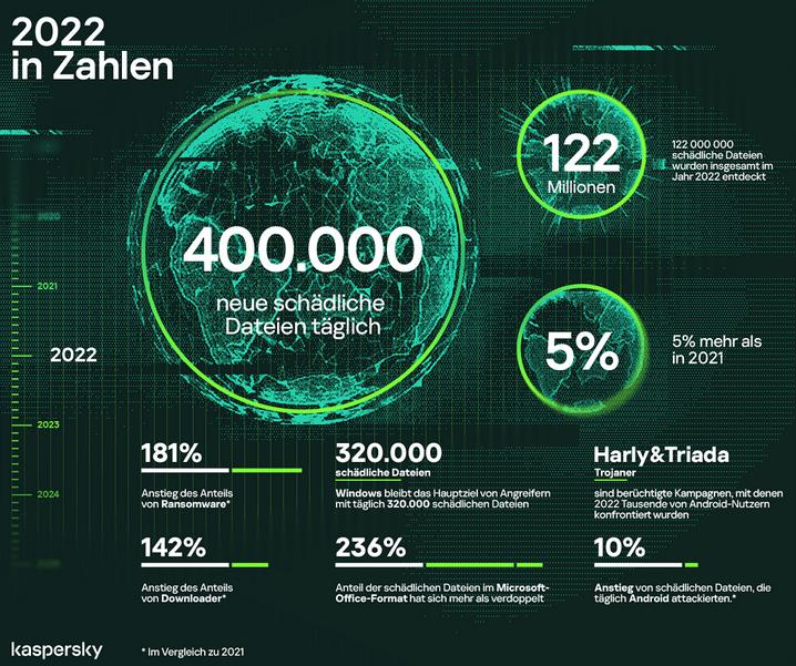
2022: 400.000 neue Malware-Dateien pro Tag!
Das aktuelle Kaspersky Security Bulletin verzeichnet einen Anstieg um 5 Prozent bei Malware und plus von 181 Prozent bei Ransomware im Vergleich zum Vorjahr 2021. Das sind durchschnittlich etwa 400.000 Malware-Dateien pro Tag oder fast 5 Schädlinge pro Sekunde.
#security #malware #Virus #ransomware #sicherheit
https://b2b-cyber-security.de/2022-400-000-neue-malware-dateien-pro-tag/
2022: 400.000 neue Malware-Dateien pro Tag! - B2B Cyber Security
Durchschnittlich gibt es etwa 400.000 neue Malware-Dateien pro Tag - Kaspersky zählt 2022 ein plus von 181 Prozent bei Ransomware.Selinger93 (MedPressIT GbR)
Mehr Kohle-Schiffe für Deutschland
Unsere grassierende Inkompetenz in Sachen Mathematik ist kein rein akademisches Problem, sie hat dramatische Konsequenzen, auch für die deutsche Politik. Dabei geht es nicht etwa um Fehler bei den letzten Stellen hinterm Komma, es geht um das Verkennen von Größenordnungen.
Diese kognitive Behinderung führt zu katastrophalen Entscheidungen durch unsere Politiker. Da aber die Mehrheit der Bevölkerung auch nicht besser rechnen kann, ist sie nicht in der Lage, das Versagen der Verantwortlichen zu erkennen und sie dafür zur Rechenschaft zu ziehen. Dazu ein aktuelles Beispiel.

#Achgut #Kohle #Deutschland #Energieversorgung #Energiepolitik
https://www.achgut.com/artikel/mehr_kohle_schiffe_fuer_deutschland/


